
People's Daily Online, Beijing, May 10 (Wen Lu, Qing Yang) According to the website of the Central Meteorological Observatory, yesterday, heavy rainfall occurred in Guangxi, Hainan, Yunnan and other places, and strong winds and sandstorms occurred in Inner Mongolia, Gansu and other places. It is expected that there will be heavy rainfall in the southern region in the next three days. Pay attention to the possible flash floods, geological disasters and urban and rural waterlogging caused by local heavy rainfall; there will be strong winds and strong convective weather in North and Northeast China, and disaster prevention measures will be taken; Xinjiang, Inner Mongolia , Gansu, Ningxia, Shaanxi and northern North China and other places are concerned about the impact of sand and dust weather on human health and transportation. In addition, attention is paid to the mitigating effect of rainfall on drought conditions in eastern Yunnan.
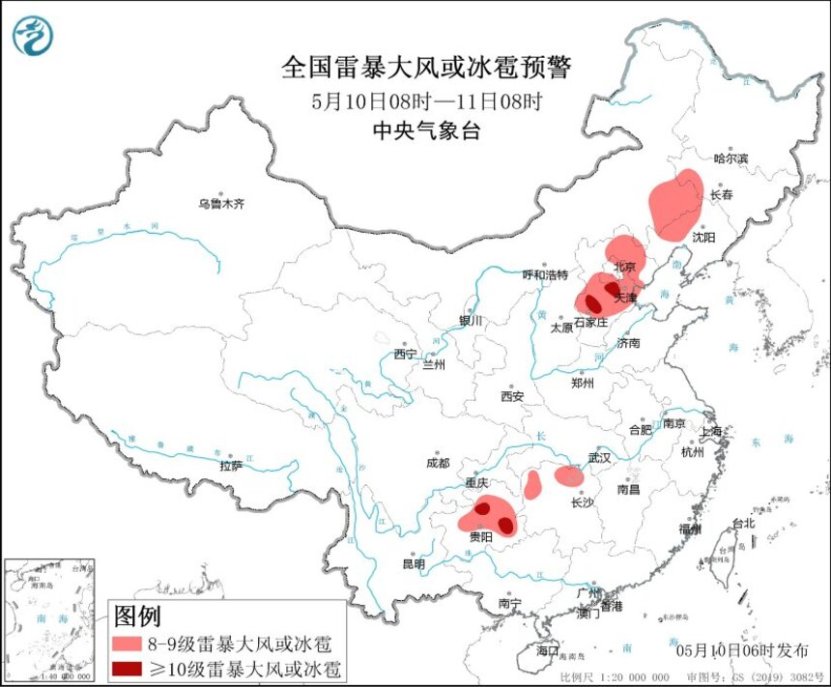
National thunderstorm, wind or hail warning map (08:00 on May 10 – 08:00 on May 11)
There is heavy rainfall in the south and strong convection in the north and northeast of China.
From May 10th to 12th, there will be a new round of heavy precipitation in the southern region, including the southern Sichuan Basin, southern Chongqing, Guizhou, Hunan, southern Hubei, Jiangxi, southern Anhui, Zhejiang, western Fujian, Guangxi, Guangdong and other places. There were heavy to heavy rains in some areas, and heavy rains in some places; the above-mentioned areas were locally accompanied by strong convective weather such as short-term heavy precipitation, thunderstorms and strong winds.
From May 10th to 11th, there will be showers or thundershowers in North China, Northeast China, Huanghuai and other places. Locally there will be moderate to heavy rain accompanied by strong convective weather such as thunderstorms, strong winds or hail. Among them, from 08:00 on May 10 to 08:00 on May 11, parts of southeastern Inner Mongolia, western Jilin, northern and western Liaoning, central and northern Hebei, Beijing, Tianjin, northern and western Hunan, central eastern and northwest Guizhou, etc. There will be thunderstorms and gales of magnitude 8 to 10 or hail, with local thunderstorms and gales of magnitude 10 or above in central Hebei, northern and southeastern Guizhou, and the maximum wind force reaching magnitude 11. The Central Meteorological Observatory will continue to issue blue warnings for severe convective weather at 06:00 on May 10.
In addition, from May 10 to 12, some areas in eastern Tibet, central and eastern Qinghai, and the western Sichuan Plateau experienced moderate to heavy snow or sleet, with localized heavy snowfall.
There are strong winds in northwest, north, northeast and other places
It is expected that from May 10 to 11, there will be level 5 to 6 winds and gusts of 7 in parts of eastern Xinjiang and southern Xinjiang basins, central and eastern northwest regions, most of Inner Mongolia, northeastern regions, central and northern and eastern North China, Huanghuai and other places. Strong winds of magnitude ~9; there are sand and dust weather in southern and eastern Xinjiang, central and western Inner Mongolia, Ningxia, central and northern Shaanxi, northern North China and other places; there are strong winds of magnitude 7~8 and gusts of magnitude 9 in the Bohai Sea, Bohai Strait, northern and central Yellow Sea Strong winds; there are winds of magnitude 6 to 7 and gusts of magnitude 8 in the eastern Yellow Sea, most of the East China Sea, and the Taiwan Strait. The Central Meteorological Observatory will continue to issue blue warnings for strong winds at 06:00 on May 10.

National strong wind forecast map (08:00 on May 10th – 08:00 on May 11th)
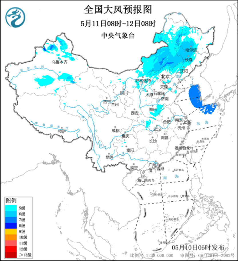
National strong wind forecast map (08:00 on May 11th – 08:00 on May 12th)
(Editor's note: Wen Lu, Deng Zhihui)
Share so more people can see it 
#heavy #rainfall #south #strong #convection #north #northeast #ChinaSociety #Rule #LawPeople39s #Daily #Online

